This is an official economic forum, on which the previously developed and approved plans for the total occupation and division of Ukraine were published.
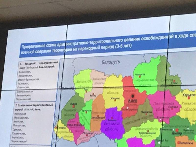
At the Economic Forum in St. Petersburg, they showed a scheme for the administrative-territorial division of Ukraine in the event of its occupation.
Russian propagandist Oleksandr Kots published the map with the division of Ukraine.
The Kremlin mouthpiece said this is a map of the dismemberment of the "former Ukraine." The scheme is designed for a "transitional period" - 3-5 years.
The map shows that the occupiers dreamed of dividing Ukraine into so-called districts. Number 1 is the so-called "Western Territorial District," consisting of eight regions (Volyn, Transcarpathian, Ivano-Frankivsk, Lviv, Rivne, Ternopil, Khmelnytskyi, Chernivtsi), with the center in the city of Khmelnitsky.
Number 2 includes the so-called "Central Territorial District" which also includes eight regions (Vinnytsia, Zhytomyr, Kyiv, Poltava, Sumy, Kharkiv, Cherkasy, Chernihiv), with the center in the city of Kyiv. Other counties are not visible in the photo.
Commenting on this map, Ukrainian political scientist Oleksiy Golubutsky suggested sending it to politicians from those countries that offer Ukraine to "reconcile with the Russian Federation."
This scheme clearly and unequivocally shows what will happen if Russia is not neutralized, if Ukraine does not win
Oleksiy Golubutsky


