
Walking routes through Odessa region were compiled by Volodymyr Poltorak, Candidate of Historical Sciences, Associate Professor of the Department of History of Ukraine, Odessa National University named after Mechnikov. Discover the following routes: Kuyalnik and Dniester Estuary
Kuyalnik
from Korsuntsy to Zhevakhova mountain (14 km)

Walking one-day route to the Eastern suburbs of Odessa: Peresyp. It was here from the XV to the XVIII century that the battles of the Cossack-Ottoman wars took place.
The area is also famous for being the deepest land point of modern Ukraine - is located at a depth of 7 meters below sea level. The strategic route from Central Europe to the Crimea passed through Peresyp, therefore, the struggle for control of this isthmus led to numerous battles.
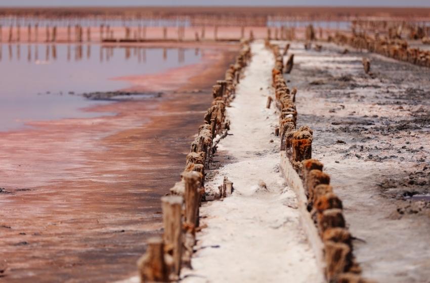
Kuyalnyk estuary became a place of extraction of salt - the most important product for the economy of late medieval and early modern Ukraine.
The route is best held in March-June and September-October. The beginning of the route: the railway station Odessa-East. End point: a memorial cross at the site of the victory of the detachment led by Semyon Paliy in 1691 year. A third of the route passes along the shore of the estuary.
The most interesting objects along the route: the house of the joint-stock board society of salt industries on Kuyalnik, the remains of salt industries, the buildings of the resort of the XIX-XX centuries, the site of the ancient temple on Zhevahova Hill, the only natural sandy beach in Odessa - Luzanovsky.


Dniester estuary 1
from Belgorod to Zatoka (27 km)

Walking one-day or two-day route along the west coast Dniester estuary. This is an area where from antiquity to the Middle Ages there was a water trade route from the Black Sea to the Carpathians and land route from the Eurasian steppes to the Balkan Peninsula.
Landscape is moderately cut, mostly sandy soils. Here in the Middle Ages the existence of the Kamr al-Kum desert is recorded. Now the coast of the estuary is mostly lined with vineyards and orchards, as well as forests to strengthen the high shores.
The walking tour can be organized in both directions, from Zatoka and from Belgorod-Dniesterovsky. You can stay overnight on the shores of the estuary near Shabo. The most time in terms of cognitive tourism can take a review the city of Belgorod-Dniesterovsky, which houses numerous monuments of antiquity, medieval and modern times. Excavations of the ancient city of Tyra and medieval fortresses are located in the city center and need especially careful inspection.
The coast from Belgorod to Shabo is interesting from the historical and naturalistic sides. Here the road passes along the edge of the estuary, you can find white and gray herons, pelicans. The area is a former desert, from where sand was taken to Mediterranean countries for the manufacture of hourglasses.
Shabo is a colony of Swiss settlers, famous for winemaking, and recently here is the center for the production of dairy cheeses. The way to Zatoka is high cliffs and floodplains. In Zatoka you can go to the beach and see the bridge over the Tsaregradsky mouth of Dniester estuary.


Dniester estuary 2
from Mayaky to Ovidiopol (30 km)

Walking one-day or two-day route along the East coast Dniester estuary with a panoramic view of the Dniester delta. A number of inhabited points founded by Lithuanians (Mayaky-Black City), Tatars (Ovidiopol Adzhider), Zaporozhian fishermen (Kalaglia), retired sailors and German colonists (Nadlymanske).
The landscape is cut by deep ravines, the shore is high. Afforestations, vineyards and fields form the colours of the landscape. In Mayaky you can see the bridge across the Dniester, astronomical observatory, and then go to see the panorama of the Dniester Delta.
Picturesque shore above the Karagol Bay of the Dniester estuary attracts ornithologists. With strong optics, you can see well from above coast covered with reeds.
Along the way you should inspect the excavations of ancient settlements as well Ovidiopol Fortress, founded in 1793.
In the cozy southern Ukrainian town of Ovidiopol on the shores of the estuary the route can be completed with a photo in front of an ancient Roman monument to the poet Ovid, who, according to a legend, spent the last years of his life it is in this area.


To be continued...